


Téléthon 2023

norbertmarteau
Gebruiker
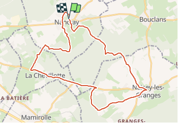

Lengte
21 km

Max. hoogte
492 m

Positief hoogteverschil
289 m
Km-Effort
25 km

Min. hoogte
400 m

Negatief hoogteverschil
285 m
Boucle
Ja
Datum van aanmaak :
2023-12-08 08:30:23.428
Laatste wijziging :
2023-12-08 08:36:41.776
1h42
Moeilijkheid : Medium

Gratisgps-wandelapplicatie
 SityTrail
IGN / Geografische instituten
SityTrail Plus
De wereld gaat voor u open
Over ons
Tocht Mountainbike van 21 km beschikbaar op Bourgondië-Franche-Comté, Doubs, Nancray. Deze tocht wordt voorgesteld door norbertmarteau.
Beschrijving
Parcours de la rando VTT nocturne de l'édition Naisey Les Granges - Nancray du Téléthon 2023.
Foto's

Plaatsbepaling
Land:
France
Regio :
Bourgondië-Franche-Comté
Departement/Provincie :
Doubs
Gemeente :
Nancray
Locatie:
Unknown
Vertrek:(Dec)
Vertrek:(UTM)
286766 ; 5236400 (32T) N.
Opmerkingen