


Trace Reco G4 Poey Beyrie Guy

mitch1952
Gebruiker
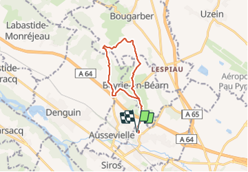

Lengte
11,6 km

Max. hoogte
275 m

Positief hoogteverschil
288 m
Km-Effort
15,5 km

Min. hoogte
160 m

Negatief hoogteverschil
287 m
Boucle
Ja
Datum van aanmaak :
2023-12-08 07:49:10.0
Laatste wijziging :
2023-12-08 15:28:08.32

Gratisgps-wandelapplicatie
 SityTrail
IGN / Geografische instituten
SityTrail Plus
De wereld gaat voor u open
Over ons
Tocht van 11,6 km beschikbaar op Nieuw-Aquitanië, Pyrénées-Atlantiques, Poey-de-Lescar. Deze tocht wordt voorgesteld door mitch1952.
Plaatsbepaling
Land:
France
Regio :
Nieuw-Aquitanië
Departement/Provincie :
Pyrénées-Atlantiques
Gemeente :
Poey-de-Lescar
Locatie:
Unknown
Vertrek:(Dec)
Vertrek:(UTM)
705004 ; 4803438 (30T) N.
Opmerkingen