


Lentisques - Pic d’Aurelle

GeorgesV.
Gebruiker
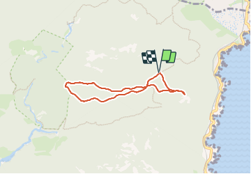

Lengte
5,9 km

Max. hoogte
295 m

Positief hoogteverschil
115 m
Km-Effort
7,4 km

Min. hoogte
234 m

Negatief hoogteverschil
114 m
Boucle
Ja
Datum van aanmaak :
2023-12-11 08:02:54.0
Laatste wijziging :
2023-12-11 10:10:49.836

Gratisgps-wandelapplicatie
 SityTrail
IGN / Geografische instituten
SityTrail Plus
De wereld gaat voor u open
Over ons
Tocht van 5,9 km beschikbaar op Provence-Alpes-Côte d'Azur, Var, Saint-Raphaël. Deze tocht wordt voorgesteld door GeorgesV..
Beschrijving
Belle randonnée de 6 km et 150 m de D
Sentiers en balcon, jolis points de vue.
Plaatsbepaling
Land:
France
Regio :
Provence-Alpes-Côte d'Azur
Departement/Provincie :
Var
Gemeente :
Saint-Raphaël
Locatie:
Unknown
Vertrek:(Dec)
Vertrek:(UTM)
330834 ; 4815143 (32T) N.
Opmerkingen