


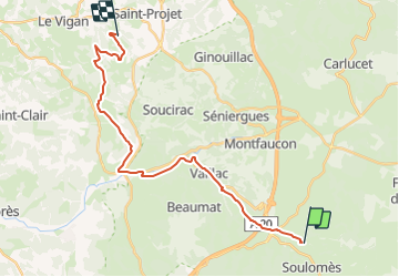
J2 - Lot - Labastide-Murat > Le Vigan

aeldin
Gebruiker

Lengte
24 km

Max. hoogte
447 m

Positief hoogteverschil
376 m
Km-Effort
29 km

Min. hoogte
228 m

Negatief hoogteverschil
514 m
Boucle
Neen
Datum van aanmaak :
2023-12-16 11:53:36.893
Laatste wijziging :
2023-12-19 09:12:34.43
3h48
Moeilijkheid : Medium

Gratisgps-wandelapplicatie
 SityTrail
IGN / Geografische instituten
SityTrail Plus
De wereld gaat voor u open
Over ons
Tocht Paardrijden van 24 km beschikbaar op Occitanië, Lot, Cœur de Causse. Deze tocht wordt voorgesteld door aeldin.

Plaatsbepaling
Land:
France
Regio :
Occitanië
Departement/Provincie :
Lot
Gemeente :
Cœur de Causse
Locatie:
Labastide-Murat
Vertrek:(Dec)
Vertrek:(UTM)
388011 ; 4944302 (31T) N.
Opmerkingen