


Trip_2023-10-10_ebike-connect

topolino
Gebruiker
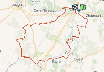

Lengte
51 km

Max. hoogte
175 m

Positief hoogteverschil
475 m
Km-Effort
57 km

Min. hoogte
88 m

Negatief hoogteverschil
475 m
Boucle
Ja
Datum van aanmaak :
2023-12-23 12:15:54.099
Laatste wijziging :
2023-12-23 12:16:51.198
3h58
Moeilijkheid : Zeer moeilijk

Gratisgps-wandelapplicatie
 SityTrail
IGN / Geografische instituten
SityTrail Plus
De wereld gaat voor u open
Over ons
Tocht Mountainbike van 51 km beschikbaar op Nieuw-Aquitanië, Vienne, Vivonne. Deze tocht wordt voorgesteld door topolino.
Plaatsbepaling
Land:
France
Regio :
Nieuw-Aquitanië
Departement/Provincie :
Vienne
Gemeente :
Vivonne
Locatie:
Unknown
Vertrek:(Dec)
Vertrek:(UTM)
289986 ; 5144331 (31T) N.
Opmerkingen