


chamadelle

luluc
Gebruiker
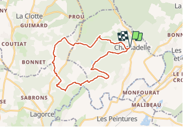

Lengte
16,4 km

Max. hoogte
87 m

Positief hoogteverschil
235 m
Km-Effort
19,5 km

Min. hoogte
15 m

Negatief hoogteverschil
234 m
Boucle
Ja
Datum van aanmaak :
2023-12-23 08:47:41.84
Laatste wijziging :
2023-12-23 14:31:55.588
5h43
Moeilijkheid : Zeer moeilijk

Gratisgps-wandelapplicatie
 SityTrail
IGN / Geografische instituten
SityTrail Plus
De wereld gaat voor u open
Over ons
Tocht Stappen van 16,4 km beschikbaar op Nieuw-Aquitanië, Gironde, Chamadelle. Deze tocht wordt voorgesteld door luluc .
Beschrijving
petites routes et de jolis bois.
Plaatsbepaling
Land:
France
Regio :
Nieuw-Aquitanië
Departement/Provincie :
Gironde
Gemeente :
Chamadelle
Locatie:
Unknown
Vertrek:(Dec)
Vertrek:(UTM)
729807 ; 4998545 (30T) N.
Opmerkingen