


SityTrail - J2 - Lot - Labastide-Murat > Le Vigan (Par Le Vigan)

ophness
Gebruiker
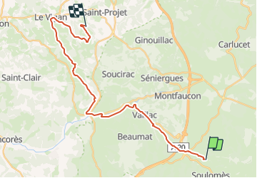

Lengte
27 km

Max. hoogte
447 m

Positief hoogteverschil
454 m
Km-Effort
34 km

Min. hoogte
228 m

Negatief hoogteverschil
590 m
Boucle
Neen
Datum van aanmaak :
2023-12-29 22:23:00.836
Laatste wijziging :
2023-12-29 22:23:18.556
4h25
Moeilijkheid : Moeilijk

Gratisgps-wandelapplicatie
 SityTrail
IGN / Geografische instituten
SityTrail Plus
De wereld gaat voor u open
Over ons
Tocht Paardrijden van 27 km beschikbaar op Occitanië, Lot, Cœur de Causse. Deze tocht wordt voorgesteld door ophness.


Plaatsbepaling
Land:
France
Regio :
Occitanië
Departement/Provincie :
Lot
Gemeente :
Cœur de Causse
Locatie:
Labastide-Murat
Vertrek:(Dec)
Vertrek:(UTM)
388011 ; 4944302 (31T) N.
Opmerkingen