


Wikiloc - Lee trail

collignpn
Gebruiker GUIDE
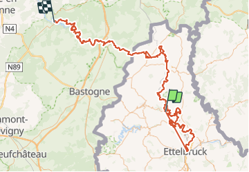

Lengte
181 km

Max. hoogte
513 m

Positief hoogteverschil
6473 m
Km-Effort
268 km

Min. hoogte
194 m

Negatief hoogteverschil
6516 m
Boucle
Neen
Datum van aanmaak :
2024-01-09 15:38:03.545
Laatste wijziging :
2024-01-09 15:38:55.83
60h47
Moeilijkheid : Zeer moeilijk

Gratisgps-wandelapplicatie
 SityTrail
IGN / Geografische instituten
SityTrail Plus
De wereld gaat voor u open
Over ons
Tocht Te voet van 181 km beschikbaar op Onbekend, Canton Wiltz, Kiischpelt. Deze tocht wordt voorgesteld door collignpn.
Plaatsbepaling
Land:
Luxembourg
Regio :
Onbekend
Departement/Provincie :
Canton Wiltz
Gemeente :
Kiischpelt
Locatie:
Unknown
Vertrek:(Dec)
Vertrek:(UTM)
286196 ; 5537320 (32U) N.
Opmerkingen