


Trace Bagneres G3 Guy

mitch1952
Gebruiker
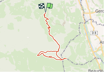

Lengte
9,9 km

Max. hoogte
1253 m

Positief hoogteverschil
561 m
Km-Effort
17,4 km

Min. hoogte
763 m

Negatief hoogteverschil
561 m
Boucle
Ja
Datum van aanmaak :
2024-01-12 08:30:15.0
Laatste wijziging :
2024-01-12 14:35:40.308

Gratisgps-wandelapplicatie
 SityTrail
IGN / Geografische instituten
SityTrail Plus
De wereld gaat voor u open
Over ons
Tocht van 9,9 km beschikbaar op Occitanië, Hautes-Pyrénées, Bagnères-de-Bigorre. Deze tocht wordt voorgesteld door mitch1952.
Plaatsbepaling
Land:
France
Regio :
Occitanië
Departement/Provincie :
Hautes-Pyrénées
Gemeente :
Bagnères-de-Bigorre
Locatie:
Unknown
Vertrek:(Dec)
Vertrek:(UTM)
266671 ; 4770882 (31T) N.
Opmerkingen