


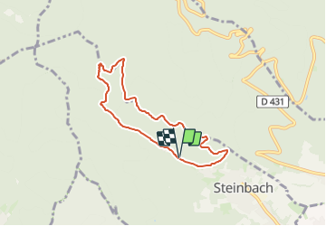
Parking Silberthal - Scheltzenburg - Cacade de l'Entzenbach et retour

patrickbeyrath
Gebruiker

Lengte
6,2 km

Max. hoogte
597 m

Positief hoogteverschil
214 m
Km-Effort
9 km

Min. hoogte
394 m

Negatief hoogteverschil
206 m
Boucle
Ja
Datum van aanmaak :
2024-01-25 06:28:13.402
Laatste wijziging :
2024-01-25 06:44:24.246
2h03
Moeilijkheid : Medium

Gratisgps-wandelapplicatie
 SityTrail
IGN / Geografische instituten
SityTrail Plus
De wereld gaat voor u open
Over ons
Tocht Te voet van 6,2 km beschikbaar op Grand Est, Haut-Rhin, Steinbach. Deze tocht wordt voorgesteld door patrickbeyrath.
Plaatsbepaling
Land:
France
Regio :
Grand Est
Departement/Provincie :
Haut-Rhin
Gemeente :
Steinbach
Locatie:
Unknown
Vertrek:(Dec)
Vertrek:(UTM)
360890 ; 5298509 (32T) N.
Opmerkingen