


2024-02-07_22h30m09_B3

LUTZMarc
Gebruiker
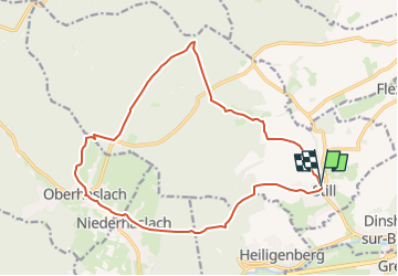

Lengte
16,8 km

Max. hoogte
387 m

Positief hoogteverschil
370 m
Km-Effort
22 km

Min. hoogte
210 m

Negatief hoogteverschil
371 m
Boucle
Ja
Datum van aanmaak :
2024-02-07 21:30:09.531
Laatste wijziging :
2024-11-01 08:43:08.5
4h56
Moeilijkheid : Medium

Gratisgps-wandelapplicatie
 SityTrail
IGN / Geografische instituten
SityTrail Plus
De wereld gaat voor u open
Over ons
Tocht Stappen van 16,8 km beschikbaar op Grand Est, Bas-Rhin, Still. Deze tocht wordt voorgesteld door LUTZMarc.
Beschrijving
Resto Le saint Florent à Oberhaslach
Plaatsbepaling
Land:
France
Regio :
Grand Est
Departement/Provincie :
Bas-Rhin
Gemeente :
Still
Locatie:
Unknown
Vertrek:(Dec)
Vertrek:(UTM)
382147 ; 5378906 (32U) N.
Opmerkingen