


Dan47 - 2024 Arbre

istadaniel
Gebruiker
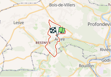

Lengte
8,8 km

Max. hoogte
260 m

Positief hoogteverschil
234 m
Km-Effort
11,9 km

Min. hoogte
137 m

Negatief hoogteverschil
227 m
Boucle
Ja
Datum van aanmaak :
2024-02-10 12:42:22.535
Laatste wijziging :
2024-11-27 08:14:12.836
2h42
Moeilijkheid : Gemakkelijk

Gratisgps-wandelapplicatie
 SityTrail
IGN / Geografische instituten
SityTrail Plus
De wereld gaat voor u open
Over ons
Tocht Te voet van 8,8 km beschikbaar op Wallonië, Namen, Profondeville. Deze tocht wordt voorgesteld door istadaniel.
Plaatsbepaling
Land:
Belgium
Regio :
Wallonië
Departement/Provincie :
Namen
Gemeente :
Profondeville
Locatie:
Arbre
Vertrek:(Dec)
Vertrek:(UTM)
629438 ; 5580931 (31U) N.
Opmerkingen