


Peissant 14 02 24

andremusin
Gebruiker
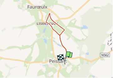

Lengte
4,8 km

Max. hoogte
148 m

Positief hoogteverschil
28 m
Km-Effort
5,2 km

Min. hoogte
134 m

Negatief hoogteverschil
30 m
Boucle
Ja
Datum van aanmaak :
2024-02-14 13:08:42.529
Laatste wijziging :
2024-02-14 14:23:42.79
1h10
Moeilijkheid : Gemakkelijk

Gratisgps-wandelapplicatie
 SityTrail
IGN / Geografische instituten
SityTrail Plus
De wereld gaat voor u open
Over ons
Tocht Stappen van 4,8 km beschikbaar op Wallonië, Henegouwen, Estinnes. Deze tocht wordt voorgesteld door andremusin.
Plaatsbepaling
Land:
Belgium
Regio :
Wallonië
Departement/Provincie :
Henegouwen
Gemeente :
Estinnes
Locatie:
Unknown
Vertrek:(Dec)
Vertrek:(UTM)
580012 ; 5578269 (31U) N.
Opmerkingen