


GR34 - 39

loic09
Gebruiker

Lengte
42 km

Max. hoogte
20 m

Positief hoogteverschil
282 m
Km-Effort
46 km

Min. hoogte
-2 m

Negatief hoogteverschil
289 m
Boucle
Neen
Datum van aanmaak :
2015-03-16 00:00:00.0
Laatste wijziging :
2015-03-16 00:00:00.0
6h00
Moeilijkheid : Medium

Gratisgps-wandelapplicatie
 SityTrail
IGN / Geografische instituten
SityTrail Plus
De wereld gaat voor u open
Over ons
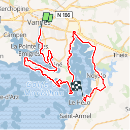
Tocht Lopen van 42 km beschikbaar op Bretagne, Morbihan, Vannes. Deze tocht wordt voorgesteld door loic09.
Beschrijving
Vannes/Le Hézo
Plaatsbepaling
Land:
France
Regio :
Bretagne
Departement/Provincie :
Morbihan
Gemeente :
Vannes
Locatie:
Unknown
Vertrek:(Dec)
Vertrek:(UTM)
518226 ; 5277692 (30T) N.
Opmerkingen