


Circuit Alsace Vosges Aubure Orbey Et Cigognes

Tourisme Equestre Alsace
Promouvoir le Tourisme Equestre en Alsace GUIDE+
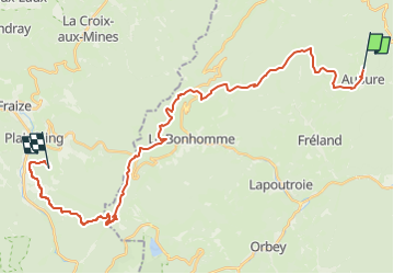

Lengte
30 km

Max. hoogte
1200 m

Positief hoogteverschil
967 m
Km-Effort
44 km

Min. hoogte
656 m

Negatief hoogteverschil
1035 m
Boucle
Neen
Datum van aanmaak :
2024-02-28 17:16:25.08
Laatste wijziging :
2024-02-28 17:24:03.374
5h44
Moeilijkheid : Moeilijk

Gratisgps-wandelapplicatie
 SityTrail
IGN / Geografische instituten
SityTrail Plus
De wereld gaat voor u open
Over ons
Tocht Paardrijden van 30 km beschikbaar op Grand Est, Haut-Rhin, Aubure. Deze tocht wordt voorgesteld door Tourisme Equestre Alsace.
Beschrijving
Circuit Entre l’Alsace et les Vosges : Etape entre Aubure et Orbey
Foto's


Plaatsbepaling
Land:
France
Regio :
Grand Est
Departement/Provincie :
Haut-Rhin
Gemeente :
Aubure
Locatie:
Unknown
Vertrek:(Dec)
Vertrek:(UTM)
367907 ; 5340252 (32U) N.
Opmerkingen