


Essai 11

patrickbeyrath
Gebruiker
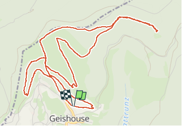

Lengte
8,4 km

Max. hoogte
1026 m

Positief hoogteverschil
353 m
Km-Effort
13,1 km

Min. hoogte
737 m

Negatief hoogteverschil
352 m
Boucle
Ja
Datum van aanmaak :
2024-03-11 09:17:35.0
Laatste wijziging :
2024-03-11 14:28:22.037

Gratisgps-wandelapplicatie
 SityTrail
IGN / Geografische instituten
SityTrail Plus
De wereld gaat voor u open
Over ons
Tocht van 8,4 km beschikbaar op Grand Est, Haut-Rhin, Geishouse. Deze tocht wordt voorgesteld door patrickbeyrath.
Beschrijving
Essai
Plaatsbepaling
Land:
France
Regio :
Grand Est
Departement/Provincie :
Haut-Rhin
Gemeente :
Geishouse
Locatie:
Unknown
Vertrek:(Dec)
Vertrek:(UTM)
355050 ; 5305318 (32T) N.
Opmerkingen