


MANDELIEU LA FORET DU GRAND DUC APRES RECONNAISSANCE

clintest
Gebruiker
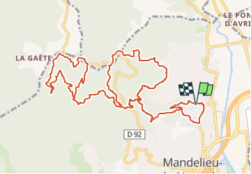

Lengte
16,9 km

Max. hoogte
458 m

Positief hoogteverschil
682 m
Km-Effort
26 km

Min. hoogte
9 m

Negatief hoogteverschil
683 m
Boucle
Ja
Datum van aanmaak :
2024-03-13 15:57:40.957
Laatste wijziging :
2024-03-13 15:58:29.198
5h54
Moeilijkheid : Medium

Gratisgps-wandelapplicatie
 SityTrail
IGN / Geografische instituten
SityTrail Plus
De wereld gaat voor u open
Over ons
Tocht Te voet van 16,9 km beschikbaar op Provence-Alpes-Côte d'Azur, Alpes-Maritimes, Mandelieu-la-Napoule. Deze tocht wordt voorgesteld door clintest.
Plaatsbepaling
Land:
France
Regio :
Provence-Alpes-Côte d'Azur
Departement/Provincie :
Alpes-Maritimes
Gemeente :
Mandelieu-la-Napoule
Locatie:
Unknown
Vertrek:(Dec)
Vertrek:(UTM)
333360 ; 4824579 (32T) N.
Opmerkingen