


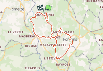
CHABANES 19 km VTT Fontans

benoit48
Gebruiker

Lengte
19,4 km

Max. hoogte
1056 m

Positief hoogteverschil
376 m
Km-Effort
24 km

Min. hoogte
926 m

Negatief hoogteverschil
376 m
Boucle
Ja
Datum van aanmaak :
2016-03-20 00:00:00.0
Laatste wijziging :
2016-03-20 00:00:00.0
1h20
Moeilijkheid : Gemakkelijk

Gratisgps-wandelapplicatie
 SityTrail
IGN / Geografische instituten
SityTrail Plus
De wereld gaat voor u open
Over ons
Tocht Mountainbike van 19,4 km beschikbaar op Occitanië, Lozère, Fontans. Deze tocht wordt voorgesteld door benoit48.
Beschrijving
Chabanes > Ponges > Montchamp > Fontans > Malaviellette > Les Estrets > Chabanes
Plaatsbepaling
Land:
France
Regio :
Occitanië
Departement/Provincie :
Lozère
Gemeente :
Fontans
Locatie:
Unknown
Vertrek:(Dec)
Vertrek:(UTM)
528219 ; 4956476 (31T) N.
Opmerkingen
Chemins roulants, accessible à tous le monde