


La Colombie Britannique Provençale

supercolas
Gebruiker GUIDE

Lengte
30 km

Max. hoogte
837 m

Positief hoogteverschil
886 m
Km-Effort
42 km

Min. hoogte
220 m

Negatief hoogteverschil
847 m
Boucle
Neen
Datum van aanmaak :
2024-03-19 11:06:54.941
Laatste wijziging :
2024-03-19 18:16:08.833
2h18
Moeilijkheid : Medium

Gratisgps-wandelapplicatie
 SityTrail
IGN / Geografische instituten
SityTrail Plus
De wereld gaat voor u open
Over ons
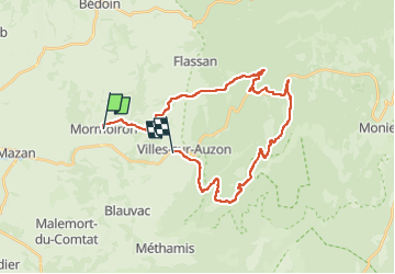
Tocht Mountainbike van 30 km beschikbaar op Provence-Alpes-Côte d'Azur, Vaucluse, Mormoiron. Deze tocht wordt voorgesteld door supercolas.
Beschrijving
Les Charbonnières / Villes sur Auzon
Retour par la route cause crevaison Maxxis
Foto's


Plaatsbepaling
Land:
France
Regio :
Provence-Alpes-Côte d'Azur
Departement/Provincie :
Vaucluse
Gemeente :
Mormoiron
Locatie:
Unknown
Vertrek:(Dec)
Vertrek:(UTM)
674815 ; 4881693 (31T) N.
Opmerkingen