


MONTAGNE DE CLARE APRES RECONNAISSANCE trajet definitif

clintest
Gebruiker
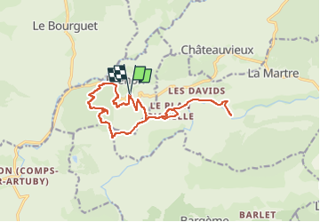

Lengte
16,5 km

Max. hoogte
1256 m

Positief hoogteverschil
654 m
Km-Effort
25 km

Min. hoogte
871 m

Negatief hoogteverschil
654 m
Boucle
Ja
Datum van aanmaak :
2024-03-23 15:08:15.4
Laatste wijziging :
2024-03-23 15:08:58.8
5h43
Moeilijkheid : Medium

Gratisgps-wandelapplicatie
 SityTrail
IGN / Geografische instituten
SityTrail Plus
De wereld gaat voor u open
Over ons
Tocht Te voet van 16,5 km beschikbaar op Provence-Alpes-Côte d'Azur, Var, Brenon. Deze tocht wordt voorgesteld door clintest.
Plaatsbepaling
Land:
France
Regio :
Provence-Alpes-Côte d'Azur
Departement/Provincie :
Var
Gemeente :
Brenon
Locatie:
Unknown
Vertrek:(Dec)
Vertrek:(UTM)
302294 ; 4848774 (32T) N.
Opmerkingen