


Trace M1 Berges du Gave Guy

mitch1952
Gebruiker
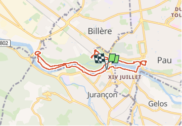

Lengte
9,6 km

Max. hoogte
208 m

Positief hoogteverschil
103 m
Km-Effort
11 km

Min. hoogte
163 m

Negatief hoogteverschil
104 m
Boucle
Ja
Datum van aanmaak :
2024-03-24 13:46:43.0
Laatste wijziging :
2024-03-24 16:19:55.542

Gratisgps-wandelapplicatie
 SityTrail
IGN / Geografische instituten
SityTrail Plus
De wereld gaat voor u open
Over ons
Tocht van 9,6 km beschikbaar op Nieuw-Aquitanië, Pyrénées-Atlantiques, Jurançon. Deze tocht wordt voorgesteld door mitch1952.
Plaatsbepaling
Land:
France
Regio :
Nieuw-Aquitanië
Departement/Provincie :
Pyrénées-Atlantiques
Gemeente :
Jurançon
Locatie:
Unknown
Vertrek:(Dec)
Vertrek:(UTM)
711874 ; 4796704 (30T) N.
Opmerkingen