


vtt_vallee_dirazakun-6733481-1711301926-61

topolino
Gebruiker
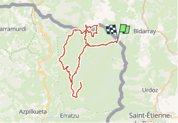

Lengte
43 km

Max. hoogte
1085 m

Positief hoogteverschil
1523 m
Km-Effort
63 km

Min. hoogte
168 m

Negatief hoogteverschil
1505 m
Boucle
Ja
Datum van aanmaak :
2024-03-24 17:39:18.188
Laatste wijziging :
2024-03-24 17:39:36.131
4h22
Moeilijkheid : Zeer moeilijk

Gratisgps-wandelapplicatie
 SityTrail
IGN / Geografische instituten
SityTrail Plus
De wereld gaat voor u open
Over ons
Tocht Mountainbike van 43 km beschikbaar op Nieuw-Aquitanië, Pyrénées-Atlantiques, Bidarray. Deze tocht wordt voorgesteld door topolino.
Plaatsbepaling
Land:
France
Regio :
Nieuw-Aquitanië
Departement/Provincie :
Pyrénées-Atlantiques
Gemeente :
Bidarray
Locatie:
Unknown
Vertrek:(Dec)
Vertrek:(UTM)
630833 ; 4790734 (30T) N.
Opmerkingen