


Florentin La Capelle (Aveyron)

houbart
Gebruiker
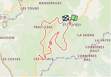

Lengte
9,8 km

Max. hoogte
659 m

Positief hoogteverschil
285 m
Km-Effort
13,6 km

Min. hoogte
422 m

Negatief hoogteverschil
285 m
Boucle
Ja
Datum van aanmaak :
2024-03-26 08:32:56.871
Laatste wijziging :
2024-03-26 08:39:32.903
3h05
Moeilijkheid : Moeilijk

Gratisgps-wandelapplicatie
 SityTrail
IGN / Geografische instituten
SityTrail Plus
De wereld gaat voor u open
Over ons
Tocht Stappen van 9,8 km beschikbaar op Occitanië, Aveyron, Florentin-la-Capelle. Deze tocht wordt voorgesteld door houbart.
Plaatsbepaling
Land:
France
Regio :
Occitanië
Departement/Provincie :
Aveyron
Gemeente :
Florentin-la-Capelle
Locatie:
Unknown
Vertrek:(Dec)
Vertrek:(UTM)
470734 ; 4941838 (31T) N.
Opmerkingen