


test dimanche 07/04

Doubotis
Gebruiker ADMIN
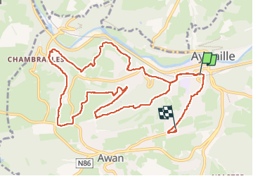

Lengte
12,3 km

Max. hoogte
292 m

Positief hoogteverschil
366 m
Km-Effort
16,9 km

Min. hoogte
124 m

Negatief hoogteverschil
281 m
Boucle
Neen
Datum van aanmaak :
2024-04-07 10:48:37.165
Laatste wijziging :
2024-04-07 13:38:38.741
2h48
Moeilijkheid : Moeilijk

Gratisgps-wandelapplicatie
 SityTrail
IGN / Geografische instituten
SityTrail Plus
De wereld gaat voor u open
Over ons
Tocht Stappen van 12,3 km beschikbaar op Wallonië, Luik, Aywaille. Deze tocht wordt voorgesteld door Doubotis.
Plaatsbepaling
Land:
Belgium
Regio :
Wallonië
Departement/Provincie :
Luik
Gemeente :
Aywaille
Locatie:
Unknown
Vertrek:(Dec)
Vertrek:(UTM)
689674 ; 5594635 (31U) N.
Opmerkingen