


Chabeuil circuit des renards

LydiaMich
Gebruiker
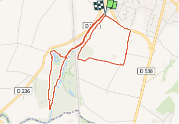

Lengte
6 km

Max. hoogte
199 m

Positief hoogteverschil
37 m
Km-Effort
6,5 km

Min. hoogte
180 m

Negatief hoogteverschil
37 m
Boucle
Ja
Datum van aanmaak :
2024-04-11 12:10:45.265
Laatste wijziging :
2024-04-11 14:21:16.852
2h10
Moeilijkheid : Gemakkelijk

Gratisgps-wandelapplicatie
 SityTrail
IGN / Geografische instituten
SityTrail Plus
De wereld gaat voor u open
Over ons
Tocht Stappen van 6 km beschikbaar op Auvergne-Rhône-Alpes, Drôme, Chabeuil. Deze tocht wordt voorgesteld door LydiaMich .
Beschrijving
passage à guet infranchissable
Plaatsbepaling
Land:
France
Regio :
Auvergne-Rhône-Alpes
Departement/Provincie :
Drôme
Gemeente :
Chabeuil
Locatie:
Unknown
Vertrek:(Dec)
Vertrek:(UTM)
658612 ; 4973369 (31T) N.
Opmerkingen