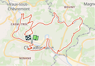
RB-Lg-21- Chaudfontaine - Via raccourci 2 - 2024-04-24

GR Rando (plus commercialisé)
Randonnez sur et autour des GR ® wallons (Sentiers de Grande Randonnée). PRO


4h41
Moeilijkheid : Onbekend

Gratisgps-wandelapplicatie
 SityTrail
IGN / Geografische instituten
SityTrail Plus
De wereld gaat voor u open
Over ons
Tocht Stappen van 14,7 km beschikbaar op Wallonië, Luik, Chaudfontaine. Deze tocht wordt voorgesteld door GR Rando (plus commercialisé).
Beschrijving
Le dénivelé de cette boucle sera estompé par le spectacle offert par les nombreux panoramas et autres lieux variés aux ambiances étonnantes, notamment le parc dédié aux artistes, le vieux cimetière du thier de la Chapelle, l’ancienne basilique de Vauxsous- Chèvremont, le fort, la ferme du Haras, les vallons forestiers profonds, les landes calaminaires ou encore le pont du Diable.
Plaatsbepaling
Opmerkingen