


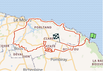
Anse à l’eau

sameja
Gebruiker

Lengte
40 km

Max. hoogte
54 m

Positief hoogteverschil
419 m
Km-Effort
46 km

Min. hoogte
-4 m

Negatief hoogteverschil
386 m
Boucle
Neen
Datum van aanmaak :
2024-04-21 11:25:33.0
Laatste wijziging :
2024-04-28 21:18:27.473
4h25
Moeilijkheid : Medium

Gratisgps-wandelapplicatie
 SityTrail
IGN / Geografische instituten
SityTrail Plus
De wereld gaat voor u open
Over ons
Tocht Mountainbike van 40 km beschikbaar op Guadeloupe, Onbekend, Saint-François. Deze tocht wordt voorgesteld door sameja.
Beschrijving
La boucle
Foto's


Plaatsbepaling
Land:
France
Regio :
Guadeloupe
Departement/Provincie :
Onbekend
Gemeente :
Saint-François
Locatie:
Unknown
Vertrek:(Dec)
Vertrek:(UTM)
685085 ; 1803550 (20Q) N.
Opmerkingen