


Mougin - parc de la Valmasque

GeorgesV.
Gebruiker
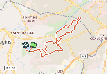

Lengte
10,8 km

Max. hoogte
237 m

Positief hoogteverschil
264 m
Km-Effort
14,3 km

Min. hoogte
159 m

Negatief hoogteverschil
252 m
Boucle
Ja
Datum van aanmaak :
2024-04-29 06:52:36.0
Laatste wijziging :
2024-04-29 10:34:08.451

Gratisgps-wandelapplicatie
 SityTrail
IGN / Geografische instituten
SityTrail Plus
De wereld gaat voor u open
Over ons
Tocht van 10,8 km beschikbaar op Provence-Alpes-Côte d'Azur, Alpes-Maritimes, Mougins. Deze tocht wordt voorgesteld door GeorgesV..
Plaatsbepaling
Land:
France
Regio :
Provence-Alpes-Côte d'Azur
Departement/Provincie :
Alpes-Maritimes
Gemeente :
Mougins
Locatie:
Unknown
Vertrek:(Dec)
Vertrek:(UTM)
339588 ; 4829004 (32T) N.
Opmerkingen