


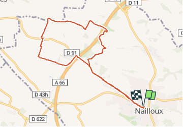
PR sud NAILLOUX

Bénédicte Guiu
Gebruiker

Lengte
10,4 km

Max. hoogte
289 m

Positief hoogteverschil
181 m
Km-Effort
12,8 km

Min. hoogte
207 m

Negatief hoogteverschil
180 m
Boucle
Ja
Datum van aanmaak :
2024-03-24 10:26:21.015
Laatste wijziging :
2024-05-08 16:55:11.118
1h11
Moeilijkheid : Medium

Gratisgps-wandelapplicatie
 SityTrail
IGN / Geografische instituten
SityTrail Plus
De wereld gaat voor u open
Over ons
Tocht Lopen van 10,4 km beschikbaar op Occitanië, Haute-Garonne, Nailloux. Deze tocht wordt voorgesteld door Bénédicte Guiu.
Plaatsbepaling
Land:
France
Regio :
Occitanië
Departement/Provincie :
Haute-Garonne
Gemeente :
Nailloux
Locatie:
Unknown
Vertrek:(Dec)
Vertrek:(UTM)
388286 ; 4801380 (31T) N.
Opmerkingen