


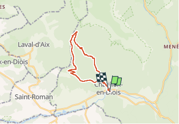
col de Caux boucle au départ de Châtillon

scalpy
Gebruiker

Lengte
11,7 km

Max. hoogte
1160 m

Positief hoogteverschil
636 m
Km-Effort
20 km

Min. hoogte
558 m

Negatief hoogteverschil
613 m
Boucle
Ja
Datum van aanmaak :
2024-05-12 08:24:31.756
Laatste wijziging :
2024-05-12 12:39:00.783
4h13
Moeilijkheid : Medium

Gratisgps-wandelapplicatie
 SityTrail
IGN / Geografische instituten
SityTrail Plus
De wereld gaat voor u open
Over ons
Tocht Stappen van 11,7 km beschikbaar op Auvergne-Rhône-Alpes, Drôme, Châtillon-en-Diois. Deze tocht wordt voorgesteld door scalpy.
Beschrijving
jolie boucle avec de beaux panorama a l'aller jusqu'au Dévoluy
Plaatsbepaling
Land:
France
Regio :
Auvergne-Rhône-Alpes
Departement/Provincie :
Drôme
Gemeente :
Châtillon-en-Diois
Locatie:
Châtillon-en-Diois
Vertrek:(Dec)
Vertrek:(UTM)
696986 ; 4951904 (31T) N.
Opmerkingen