


2024-05-21

rando30129
Gebruiker
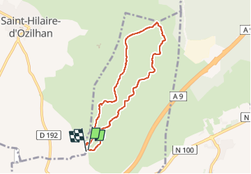

Lengte
7,4 km

Max. hoogte
146 m

Positief hoogteverschil
110 m
Km-Effort
8,9 km

Min. hoogte
54 m

Negatief hoogteverschil
112 m
Boucle
Ja
Datum van aanmaak :
2024-05-21 12:20:15.105
Laatste wijziging :
2024-05-21 15:10:08.292
2h48
Moeilijkheid : Medium

Gratisgps-wandelapplicatie
 SityTrail
IGN / Geografische instituten
SityTrail Plus
De wereld gaat voor u open
Over ons
Tocht Stappen van 7,4 km beschikbaar op Occitanië, Gard, Fournès. Deze tocht wordt voorgesteld door rando30129.
Plaatsbepaling
Land:
France
Regio :
Occitanië
Departement/Provincie :
Gard
Gemeente :
Fournès
Locatie:
Unknown
Vertrek:(Dec)
Vertrek:(UTM)
628902 ; 4867375 (31T) N.
Opmerkingen