


Château sur Epte et allée couverte

Fky78
Gebruiker
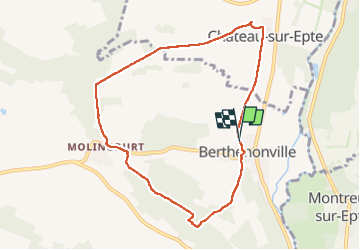

Lengte
7,8 km

Max. hoogte
136 m

Positief hoogteverschil
134 m
Km-Effort
9,6 km

Min. hoogte
45 m

Negatief hoogteverschil
140 m
Boucle
Ja
Datum van aanmaak :
2024-05-23 13:29:37.733
Laatste wijziging :
2024-05-23 16:05:28.971
2h15
Moeilijkheid : Medium

Gratisgps-wandelapplicatie
 SityTrail
IGN / Geografische instituten
SityTrail Plus
De wereld gaat voor u open
Over ons
Tocht Stappen van 7,8 km beschikbaar op Normandië, Eure, Vexin-sur-Epte. Deze tocht wordt voorgesteld door Fky78.
Plaatsbepaling
Land:
France
Regio :
Normandië
Departement/Provincie :
Eure
Gemeente :
Vexin-sur-Epte
Locatie:
Unknown
Vertrek:(Dec)
Vertrek:(UTM)
402261 ; 5448838 (31U) N.
Opmerkingen