


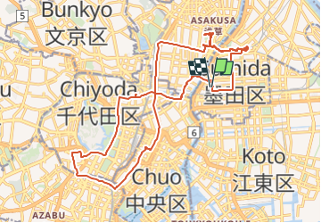
20240529 Tokio Temple

Childebert
Gebruiker

Lengte
27 km

Max. hoogte
54 m

Positief hoogteverschil
370 m
Km-Effort
32 km

Min. hoogte
-1 m

Negatief hoogteverschil
371 m
Boucle
Ja
Datum van aanmaak :
2024-05-28 23:38:40.48
Laatste wijziging :
2024-05-29 07:41:32.399
8h00
Moeilijkheid : Gemakkelijk

Gratisgps-wandelapplicatie
 SityTrail
IGN / Geografische instituten
SityTrail Plus
De wereld gaat voor u open
Over ons
Tocht Auto van 27 km beschikbaar op Tokio. Deze tocht wordt voorgesteld door Childebert.
Plaatsbepaling
Land:
Japan
Regio :
Tokio
Departement/Provincie :
Unknown
Gemeente :
Unknown
Locatie:
Unknown
Vertrek:(Dec)
Vertrek:(UTM)
391156 ; 3951141 (54S) N.
Opmerkingen