


Trace Tregastel G1 Guy

mitch1952
Gebruiker

Lengte
17,2 km

Max. hoogte
37 m

Positief hoogteverschil
166 m
Km-Effort
19,4 km

Min. hoogte
-1 m

Negatief hoogteverschil
166 m
Boucle
Ja
Datum van aanmaak :
2024-05-29 07:23:02.0
Laatste wijziging :
2024-05-29 14:09:17.869

Gratisgps-wandelapplicatie
 SityTrail
IGN / Geografische instituten
SityTrail Plus
De wereld gaat voor u open
Over ons
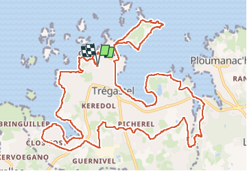
Tocht van 17,2 km beschikbaar op Bretagne, Côtes-d'Armor, Trégastel. Deze tocht wordt voorgesteld door mitch1952.
Plaatsbepaling
Land:
France
Regio :
Bretagne
Departement/Provincie :
Côtes-d'Armor
Gemeente :
Trégastel
Locatie:
Unknown
Vertrek:(Dec)
Vertrek:(UTM)
462196 ; 5408773 (30U) N.
Opmerkingen