


Heid des gattes

PatriceCocuaud
Gebruiker
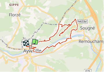

Lengte
9 km

Max. hoogte
301 m

Positief hoogteverschil
231 m
Km-Effort
12,2 km

Min. hoogte
118 m

Negatief hoogteverschil
242 m
Boucle
Ja
Datum van aanmaak :
2024-06-15 12:17:22.807
Laatste wijziging :
2024-06-15 15:14:41.36
2h56
Moeilijkheid : Gemakkelijk

Gratisgps-wandelapplicatie
 SityTrail
IGN / Geografische instituten
SityTrail Plus
De wereld gaat voor u open
Over ons
Tocht Stappen van 9 km beschikbaar op Wallonië, Luik, Aywaille. Deze tocht wordt voorgesteld door PatriceCocuaud.
Plaatsbepaling
Land:
Belgium
Regio :
Wallonië
Departement/Provincie :
Luik
Gemeente :
Aywaille
Locatie:
Unknown
Vertrek:(Dec)
Vertrek:(UTM)
689850 ; 5595074 (31U) N.
Opmerkingen