


De part et d'autre du Réaltor - 42918 - UtagawaVTT.com

Alain Derrives
Gebruiker

Lengte
37 km

Max. hoogte
262 m

Positief hoogteverschil
584 m
Km-Effort
45 km

Min. hoogte
120 m

Negatief hoogteverschil
589 m
Boucle
Ja
Datum van aanmaak :
2024-06-24 06:45:22.903
Laatste wijziging :
2024-06-24 06:45:48.447
3h06
Moeilijkheid : Zeer moeilijk

Gratisgps-wandelapplicatie
 SityTrail
IGN / Geografische instituten
SityTrail Plus
De wereld gaat voor u open
Over ons
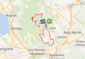
Tocht Mountainbike van 37 km beschikbaar op Provence-Alpes-Côte d'Azur, Bouches-du-Rhône, Cabriès. Deze tocht wordt voorgesteld door Alain Derrives.
Plaatsbepaling
Land:
France
Regio :
Provence-Alpes-Côte d'Azur
Departement/Provincie :
Bouches-du-Rhône
Gemeente :
Cabriès
Locatie:
Unknown
Vertrek:(Dec)
Vertrek:(UTM)
688944 ; 4814894 (31T) N.
Opmerkingen