


Ch - 4000 Saas Fee - J4 repos

guilmanu
Gebruiker
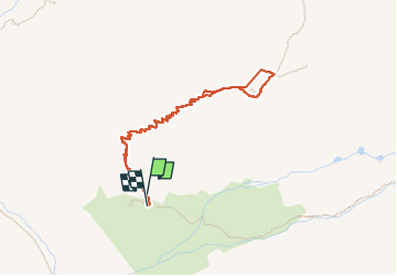

Lengte
3,9 km

Max. hoogte
3136 m

Positief hoogteverschil
427 m
Km-Effort
9,6 km

Min. hoogte
2685 m

Negatief hoogteverschil
437 m
Boucle
Ja
Datum van aanmaak :
2024-06-27 06:16:34.682
Laatste wijziging :
2024-06-28 21:00:52.556
2h03
Moeilijkheid : Gemakkelijk

Gratisgps-wandelapplicatie
 SityTrail
IGN / Geografische instituten
SityTrail Plus
De wereld gaat voor u open
Over ons
Tocht Stappen van 3,9 km beschikbaar op Valais/Wallis, Visp, Täsch. Deze tocht wordt voorgesteld door guilmanu.
Plaatsbepaling
Land:
Switzerland
Regio :
Valais/Wallis
Departement/Provincie :
Visp
Gemeente :
Täsch
Locatie:
Unknown
Vertrek:(Dec)
Vertrek:(UTM)
409480 ; 5100507 (32T) N.
Opmerkingen