


Cucuron Vaugines

counoise
Gebruiker
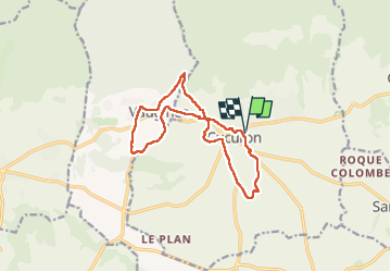

Lengte
13,8 km

Max. hoogte
451 m

Positief hoogteverschil
269 m
Km-Effort
17,4 km

Min. hoogte
289 m

Negatief hoogteverschil
269 m
Boucle
Ja
Datum van aanmaak :
2024-06-23 13:48:51.632
Laatste wijziging :
2024-06-30 18:02:04.804
2h53
Moeilijkheid : Gemakkelijk

Gratisgps-wandelapplicatie
 SityTrail
IGN / Geografische instituten
SityTrail Plus
De wereld gaat voor u open
Over ons
Tocht Stappen van 13,8 km beschikbaar op Provence-Alpes-Côte d'Azur, Vaucluse, Cucuron. Deze tocht wordt voorgesteld door counoise.
Foto's


Plaatsbepaling
Land:
France
Regio :
Provence-Alpes-Côte d'Azur
Departement/Provincie :
Vaucluse
Gemeente :
Cucuron
Locatie:
Unknown
Vertrek:(Dec)
Vertrek:(UTM)
696575 ; 4849660 (31T) N.
Opmerkingen