


2024-07-01_16h47m14_SityTrail - 4107938 - circuit-des-lacs-allos-v1

clintest
Gebruiker
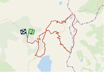

Lengte
12,9 km

Max. hoogte
2675 m

Positief hoogteverschil
619 m
Km-Effort
21 km

Min. hoogte
2108 m

Negatief hoogteverschil
618 m
Boucle
Ja
Datum van aanmaak :
2024-07-01 14:47:14.729
Laatste wijziging :
2024-07-01 14:47:16.351

Gratisgps-wandelapplicatie
 SityTrail
IGN / Geografische instituten
SityTrail Plus
De wereld gaat voor u open
Over ons
Tocht van 12,9 km beschikbaar op Provence-Alpes-Côte d'Azur, Alpes-de-Haute-Provence, Allos. Deze tocht wordt voorgesteld door clintest.
Plaatsbepaling
Land:
France
Regio :
Provence-Alpes-Côte d'Azur
Departement/Provincie :
Alpes-de-Haute-Provence
Gemeente :
Allos
Locatie:
Unknown
Vertrek:(Dec)
Vertrek:(UTM)
316173 ; 4901691 (32T) N.
Opmerkingen