


, GR233 2024 E01

michelelfn
Gebruiker
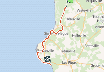

Lengte
18,7 km

Max. hoogte
84 m

Positief hoogteverschil
320 m
Km-Effort
23 km

Min. hoogte
-2 m

Negatief hoogteverschil
359 m
Boucle
Neen
Datum van aanmaak :
2024-07-03 07:53:20.322
Laatste wijziging :
2024-07-03 12:49:25.582
4h25
Moeilijkheid : Zeer moeilijk

Gratisgps-wandelapplicatie
 SityTrail
IGN / Geografische instituten
SityTrail Plus
De wereld gaat voor u open
Over ons
Tocht Stappen van 18,7 km beschikbaar op Normandië, Manche, La Hague. Deze tocht wordt voorgesteld door michelelfn.
Beschrijving
Biville Bleval
Plaatsbepaling
Land:
France
Regio :
Normandië
Departement/Provincie :
Manche
Gemeente :
La Hague
Locatie:
Vasteville
Vertrek:(Dec)
Vertrek:(UTM)
585639 ; 5494899 (30U) N.
Opmerkingen