


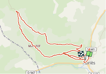
Abries Les Bertins circuit 18 VTT FFC

psesjs
Gebruiker

Lengte
13 km

Max. hoogte
2143 m

Positief hoogteverschil
598 m
Km-Effort
21 km

Min. hoogte
1551 m

Negatief hoogteverschil
593 m
Boucle
Ja
Datum van aanmaak :
2024-07-15 07:25:45.346
Laatste wijziging :
2024-07-15 09:58:22.152
2h29
Moeilijkheid : Medium

Gratisgps-wandelapplicatie
 SityTrail
IGN / Geografische instituten
SityTrail Plus
De wereld gaat voor u open
Over ons
Tocht Mountainbike van 13 km beschikbaar op Provence-Alpes-Côte d'Azur, Hautes-Alpes, Abriès-Ristolas. Deze tocht wordt voorgesteld door psesjs.
Beschrijving
Montee facile descente un peu technique
Plaatsbepaling
Land:
France
Regio :
Provence-Alpes-Côte d'Azur
Departement/Provincie :
Hautes-Alpes
Gemeente :
Abriès-Ristolas
Locatie:
Unknown
Vertrek:(Dec)
Vertrek:(UTM)
335929 ; 4962275 (32T) N.
Opmerkingen