


Trace Musculdy G3 Guy

mitch1952
Gebruiker
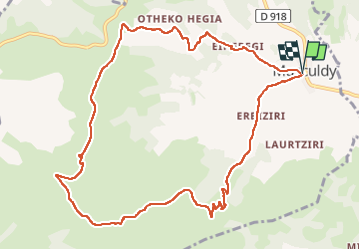

Lengte
12,6 km

Max. hoogte
700 m

Positief hoogteverschil
568 m
Km-Effort
20 km

Min. hoogte
199 m

Negatief hoogteverschil
569 m
Boucle
Ja
Datum van aanmaak :
2024-07-15 07:30:51.0
Laatste wijziging :
2024-07-15 12:30:28.021

Gratisgps-wandelapplicatie
 SityTrail
IGN / Geografische instituten
SityTrail Plus
De wereld gaat voor u open
Over ons
Tocht van 12,6 km beschikbaar op Nieuw-Aquitanië, Pyrénées-Atlantiques, Musculdy. Deze tocht wordt voorgesteld door mitch1952.
Plaatsbepaling
Land:
France
Regio :
Nieuw-Aquitanië
Departement/Provincie :
Pyrénées-Atlantiques
Gemeente :
Musculdy
Locatie:
Unknown
Vertrek:(Dec)
Vertrek:(UTM)
665212 ; 4784599 (30T) N.
Opmerkingen