


Sous l’orage

charpe
Gebruiker

Lengte
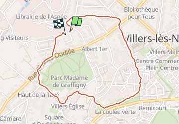
2,2 km

Max. hoogte
298 m

Positief hoogteverschil
59 m
Km-Effort
3 km

Min. hoogte
237 m

Negatief hoogteverschil
53 m
Boucle
Ja
Datum van aanmaak :
2024-07-15 16:18:00.0
Laatste wijziging :
2024-07-15 16:58:27.084
40m
Moeilijkheid : Gemakkelijk

Gratisgps-wandelapplicatie
 SityTrail
IGN / Geografische instituten
SityTrail Plus
De wereld gaat voor u open
Over ons
Tocht Stappen van 2,2 km beschikbaar op Grand Est, Meurthe-et-Moselle, Villers-lès-Nancy. Deze tocht wordt voorgesteld door charpe.
Plaatsbepaling
Land:
France
Regio :
Grand Est
Departement/Provincie :
Meurthe-et-Moselle
Gemeente :
Villers-lès-Nancy
Locatie:
Unknown
Vertrek:(Dec)
Vertrek:(UTM)
289875 ; 5395086 (32U) N.
Opmerkingen