


Thuin 24 07 24

andremusin
Gebruiker
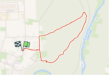

Lengte
4,1 km

Max. hoogte
205 m

Positief hoogteverschil
73 m
Km-Effort
5 km

Min. hoogte
139 m

Negatief hoogteverschil
73 m
Boucle
Ja
Datum van aanmaak :
2024-07-24 12:21:45.824
Laatste wijziging :
2024-07-24 13:49:41.496
1h09
Moeilijkheid : Gemakkelijk

Gratisgps-wandelapplicatie
 SityTrail
IGN / Geografische instituten
SityTrail Plus
De wereld gaat voor u open
Over ons
Tocht Stappen van 4,1 km beschikbaar op Wallonië, Henegouwen, Thuin. Deze tocht wordt voorgesteld door andremusin.
Plaatsbepaling
Land:
Belgium
Regio :
Wallonië
Departement/Provincie :
Henegouwen
Gemeente :
Thuin
Locatie:
Unknown
Vertrek:(Dec)
Vertrek:(UTM)
591892 ; 5578551 (31U) N.
Opmerkingen