


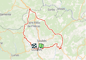
Autour de Lodève

ARVIEU
Gebruiker

Lengte
83 km

Max. hoogte
839 m

Positief hoogteverschil
1431 m
Km-Effort
102 km

Min. hoogte
155 m

Negatief hoogteverschil
1431 m
Boucle
Ja
Datum van aanmaak :
2024-07-24 19:27:37.465
Laatste wijziging :
2024-07-24 19:29:50.424
4h30
Moeilijkheid : Medium

Gratisgps-wandelapplicatie
 SityTrail
IGN / Geografische instituten
SityTrail Plus
De wereld gaat voor u open
Over ons
Tocht Fiets van 83 km beschikbaar op Occitanië, Hérault, Lodève. Deze tocht wordt voorgesteld door ARVIEU.
Beschrijving
Col du Perthus, Les Rives, le Caylar, La Vacquerie, le col du Vent,
St Privat, Fozières
Plaatsbepaling
Land:
France
Regio :
Occitanië
Departement/Provincie :
Hérault
Gemeente :
Lodève
Locatie:
Unknown
Vertrek:(Dec)
Vertrek:(UTM)
526077 ; 4841229 (31T) N.
Opmerkingen