


chatelaillon

michelbarc
Gebruiker
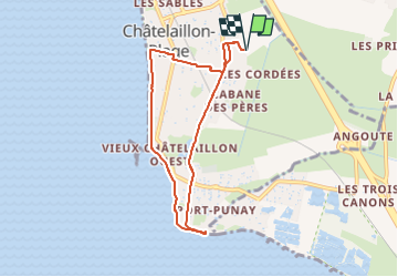

Lengte
7,2 km

Max. hoogte
21 m

Positief hoogteverschil
39 m
Km-Effort
7,7 km

Min. hoogte
1 m

Negatief hoogteverschil
39 m
Boucle
Ja
Datum van aanmaak :
2024-08-04 08:39:21.16
Laatste wijziging :
2024-08-04 10:14:23.025
1h20
Moeilijkheid : Gemakkelijk

Gratisgps-wandelapplicatie
 SityTrail
IGN / Geografische instituten
SityTrail Plus
De wereld gaat voor u open
Over ons
Tocht Mountainbike van 7,2 km beschikbaar op Nieuw-Aquitanië, Charente-Maritime, Châtelaillon-Plage. Deze tocht wordt voorgesteld door michelbarc.
Plaatsbepaling
Land:
France
Regio :
Nieuw-Aquitanië
Departement/Provincie :
Charente-Maritime
Gemeente :
Châtelaillon-Plage
Locatie:
Unknown
Vertrek:(Dec)
Vertrek:(UTM)
648615 ; 5103932 (30T) N.
Opmerkingen