


l'apartheid sur lèze 7 fait 2024

pidjam
Gebruiker
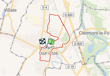

Lengte
7,2 km

Max. hoogte
171 m

Positief hoogteverschil
38 m
Km-Effort
7,8 km

Min. hoogte
158 m

Negatief hoogteverschil
39 m
Boucle
Ja
Datum van aanmaak :
2024-08-08 07:05:23.878
Laatste wijziging :
2024-08-08 09:22:55.192
1h45
Moeilijkheid : Gemakkelijk

Gratisgps-wandelapplicatie
 SityTrail
IGN / Geografische instituten
SityTrail Plus
De wereld gaat voor u open
Over ons
Tocht Stappen van 7,2 km beschikbaar op Occitanië, Haute-Garonne, Labarthe-sur-Lèze. Deze tocht wordt voorgesteld door pidjam.
Plaatsbepaling
Land:
France
Regio :
Occitanië
Departement/Provincie :
Haute-Garonne
Gemeente :
Labarthe-sur-Lèze
Locatie:
Unknown
Vertrek:(Dec)
Vertrek:(UTM)
370487 ; 4812385 (31T) N.
Opmerkingen