


Belcodène Le Garri 12 août 2014

rlebasque
Gebruiker

Lengte
13,9 km

Max. hoogte
519 m

Positief hoogteverschil
359 m
Km-Effort
18,7 km

Min. hoogte
305 m

Negatief hoogteverschil
360 m
Boucle
Ja
Datum van aanmaak :
2024-08-12 05:35:50.022
Laatste wijziging :
2024-08-12 11:06:11.533
5h29
Moeilijkheid : Moeilijk

Gratisgps-wandelapplicatie
 SityTrail
IGN / Geografische instituten
SityTrail Plus
De wereld gaat voor u open
Over ons
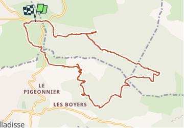
Tocht Stappen van 13,9 km beschikbaar op Provence-Alpes-Côte d'Azur, Bouches-du-Rhône, Belcodène. Deze tocht wordt voorgesteld door rlebasque.
Plaatsbepaling
Land:
France
Regio :
Provence-Alpes-Côte d'Azur
Departement/Provincie :
Bouches-du-Rhône
Gemeente :
Belcodène
Locatie:
Unknown
Vertrek:(Dec)
Vertrek:(UTM)
711112 ; 4810651 (31T) N.
Opmerkingen