


Favaritx

Vinceneux
Gebruiker

Lengte
4,6 km

Max. hoogte
35 m

Positief hoogteverschil
56 m
Km-Effort
5,4 km

Min. hoogte
3 m

Negatief hoogteverschil
52 m
Boucle
Ja
Datum van aanmaak :
2024-07-21 13:16:55.327
Laatste wijziging :
2024-09-13 13:29:49.72
2h08
Moeilijkheid : Gemakkelijk

Gratisgps-wandelapplicatie
 SityTrail
IGN / Geografische instituten
SityTrail Plus
De wereld gaat voor u open
Over ons
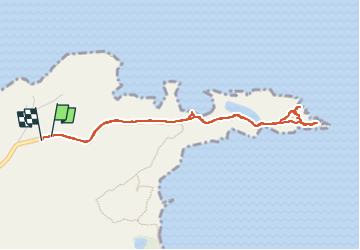
Tocht Stappen van 4,6 km beschikbaar op Balearen, Onbekend, Maó. Deze tocht wordt voorgesteld door Vinceneux.
Plaatsbepaling
Land:
Spain
Regio :
Balearen
Departement/Provincie :
Onbekend
Gemeente :
Maó
Locatie:
Unknown
Vertrek:(Dec)
Vertrek:(UTM)
606341 ; 4428045 (31S) N.
Opmerkingen