


17/08/2024 - AFF, de BEIGNON aux Forges

babeth35
Gebruiker
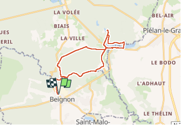

Lengte
14,5 km

Max. hoogte
173 m

Positief hoogteverschil
224 m
Km-Effort
17,5 km

Min. hoogte
74 m

Negatief hoogteverschil
224 m
Boucle
Ja
Datum van aanmaak :
2024-08-17 08:53:26.0
Laatste wijziging :
2024-08-17 15:51:27.063
4h18
Moeilijkheid : Gemakkelijk

Gratisgps-wandelapplicatie
 SityTrail
IGN / Geografische instituten
SityTrail Plus
De wereld gaat voor u open
Over ons
Tocht Stappen van 14,5 km beschikbaar op Bretagne, Morbihan, Beignon. Deze tocht wordt voorgesteld door babeth35.
Plaatsbepaling
Land:
France
Regio :
Bretagne
Departement/Provincie :
Morbihan
Gemeente :
Beignon
Locatie:
Unknown
Vertrek:(Dec)
Vertrek:(UTM)
561678 ; 5313631 (30T) N.
Opmerkingen